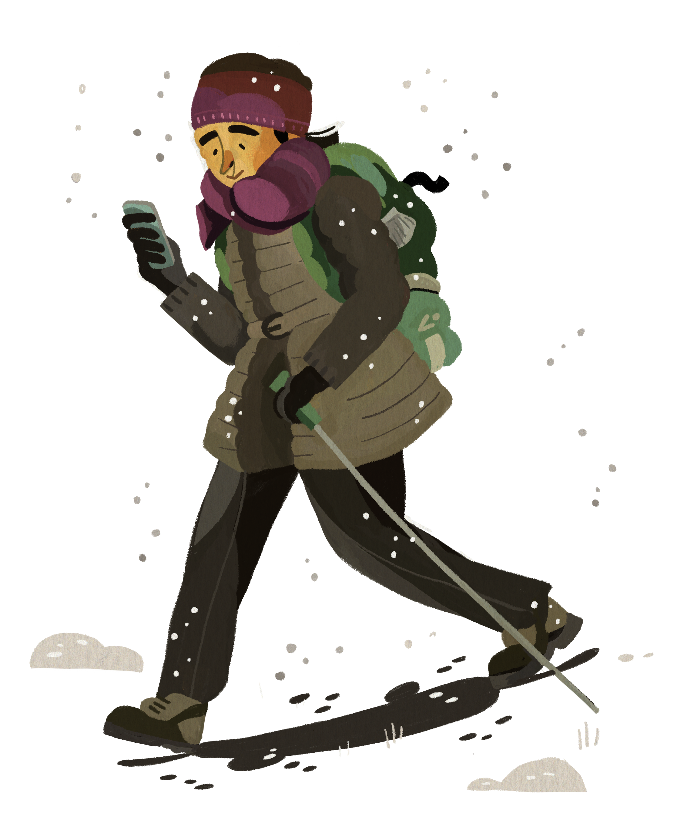
the winter way or way of the sil
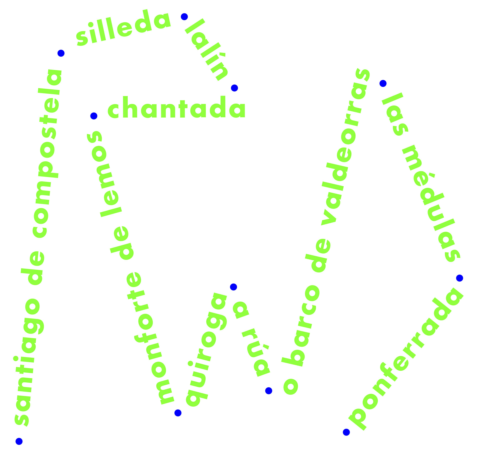
Extending for some 263 km between Ponferrada and Santiago, the WINTER WAY is one of the middle distance pilgrimage routes included in the latest campaigns to recover lost or little used pilgrimage routes, and was awarded official status in 2016. According to Pilgrimage Office statistics, in 2019 it was chosen by 1.035 pilgrims, a year-on-year rise of 47%.
This way retraces what may well be the most ancient route into Galicia from the region of El Bierzo, used by the Romans for their Via XVIII or Nova, initially tended to transport the gold extracted from the River Sil. Indeed, superb remains of the mining activity of that period can still be seen today.
Those responsible for the recovery of this way claim, albeit with little solid evidence, that it provided pilgrims with an alternative route when snowfalls blocked the French Way through O Cebreiro. This is highly unlikely if we consider that the route includes Foncebadón, which is even higher and more challenging than O Cebeiro Pass. So much so in fact, that THE WAY OF THE SIL would be a far more suitable name.
Although this has always been one of the lesser-known routes, pilgrims were able to enjoy the hospitality and services of the monasteries and hospitals dotted along the way, as well as the amenities of larger towns, in particular Monforte de Lemos.
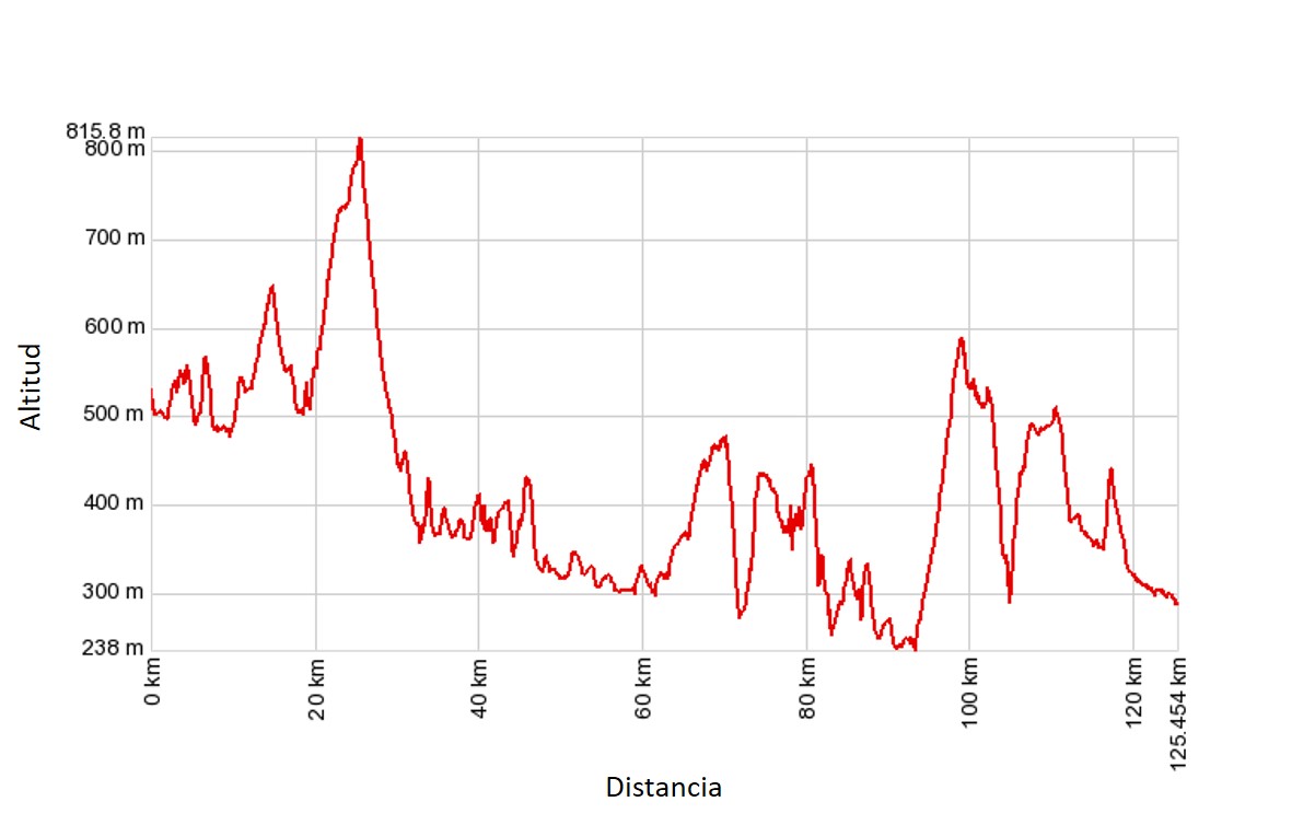
The use of the term ‘winter’ may be deceptive. You would be wrong if you thought that this way is free from any challenging uphill climbs, as they are practically continuous right from the start. In fact, the only ‘easy’ stages are to be found in Valdeorras and towards the end of the route, in the area known as Terra de Deza and after the route joins up with the Ourense Way.
On leaving Ponferrada, rather than venturing into the Valley, we advise taking the uphill route to Conratel Castle and Las Médulas. After A Rúa, the River Sil is flanked by steep banks, forcing us to walk on the slopes. We then make our way through the valleys of Lor, Cabe and Miño, in a deep ravine. The high point – literally – comes with the climb up to Monte do Faro, at an altitude of more than 1,100 metres.
![]() Why coin it the Winter Way when it would be far wiser to follow in spring or autumn (the summer heat will deceive you into thinking you are on the Silver Trail)? The name would seem to have been concocted by our enemies.
Why coin it the Winter Way when it would be far wiser to follow in spring or autumn (the summer heat will deceive you into thinking you are on the Silver Trail)? The name would seem to have been concocted by our enemies.
This is undoubtedly one of the most spectacular routes in terms of nature, as it takes us through forests of autochthonous chestnut and oak trees, or replanted woods, as well as riverbanks lined with poplar, willow, black poplar and alder trees, which eventually give way to expanses of grassland in the livestock farming regions of Deza and Trasdeza towards the end of the route.
The landscapes are equally varied, although the highlights have to be the Sil and Miño gorges, a truly spectacular sight with their hillsides covered with farming terraces leading down to huge reservoirs.
The way includes a wealth of built heritage on a par with other routes, as in addition to the traces of the former mining activity and the Roman roads (Las Médulas has been included on the UNESCO World Heritage List since 1997, or Montefurado), it also boasts the medieval monasteries of the Ribeira Sacra, nominated for inclusion on the same list in 2021.
Yet apart from all these resources, it is also an important wine tourism destination, as it boasts three winemaking regions in a relatively small area: El Bierzo, Valdeorras and, La Ribeira Sacra, an example of the so-called ‘heroic’ winemaking tradition. All three regions produce white wines using the Godello grape variety, and excellent reds made with Mencía. El Bierzo and A Ulloa are major chestnut farming areas, and the dairy industry thrives in and around the towns of Lalín and Silleda.
The traditional country and farming tracks, which include several stretches that follow the Roman roads (Codos de Belesar), provide a welcome break from other tarmacked sections. However, the creation of paths running parallel to certain roads is still pending.
Accommodation was one of the weaknesses of this route, in particular the lack of hostels, far fewer in comparison with the other ways. However, rising numbers of pilgrims have led to the emergence of new options. Moreover, the end of the traditional stretches tends to coincide with large towns (O Barco, A Rúa, Quiroga, Monforte, Chantada, Lalín) where the accommodation alternatives, which are increasingly catering to our needs, are sufficient for the time being.
Interestingly, the Winter Way takes us through all four Galician provinces, in the following order: Ourense, Lugo, Pontevedra and A Coruña.
Depending on how far we wish to walk, this Way will take between 10 and 12 days, although the accommodation options will force us to complete several long stretches of around 30 km, which contrast with other shorter ones of approximately 15 km. If we include a day at the starting point or in Monforte, and another on completion of the route, the entire experience should take around a fortnight.
 HOW TO GET TO PONFERRADA
-The city can be reached directly by Renfe’s train from Barcelona, San Sebastián or Madrid, and in the opposite direction from A Coruña, Santiago or Vigo. There is also a direct line from León.
-The coach is a cheaper and faster option. Alsa operates the service from Madrid with various departures to Galicia each day, including several from Terminal 4 at the Adolfo Suárez Airport or the Moncloa interchange, although most leave from the South Bus Station. The journey takes between 4 and 5 hours and costs from €20 to €30. There are also a number of coach services each day from León, which take between 1 hour 30 minutes and 2 hours 10 minutes (€6.40 – €9.55). Some also come from Asturias (the 3 hour journey from Oviedo costs between €18 and €23). From Santiago de Compostela, via A Coruña, there are four buses a day. The journey takes between 3 hours 40 minutes and 4 hours 30 minutes and costs €19. From A Coruña there are 8 buses a day, the fastest of which takes just 2 hours 30 minutes (fares start at €17).
sections
ponferrada – o barco
PONFERRADA-O BARCO DE VALDEORRAS STRETCH (55 km)
description
The Way starts just outside Ponferrada and crosses the Boeza over Mascarón Bridge (The French Way). The starting point is also marked in the area close to the public hostel with a large milestone, obliging us to make our way back to this point. The River Boeza soon flows into the Sil, which will be our guide on our first few tentative steps.
![]() If you have spent the night in the new area of Ponferrada and wish to avoid the long way round to Boeza Bridge, head downriver along the Sil riverside walk, either from Cubelos Bridge or the bridge on the Avenida del Castillo. Crossing the pedestrian overpass will lead you straight to the Winter Way, which runs along the south bank of the river.
If you have spent the night in the new area of Ponferrada and wish to avoid the long way round to Boeza Bridge, head downriver along the Sil riverside walk, either from Cubelos Bridge or the bridge on the Avenida del Castillo. Crossing the pedestrian overpass will lead you straight to the Winter Way, which runs along the south bank of the river.
After a delightful walk through the Sil black poplar woods, we turn south to make our way through Toral de Merayo and other valley villages, with the unwelcome company of the N 536 road. At least the vineyards will prove a more pleasant companion.
Santalla del Bierzo marks the start of a steep uphill climb to Mount Pajariel as far of Villavieja, with its Church of Santiago and Cornatel Castle. The way takes us a long way round which can be avoided by following the main road, although this is unadvisable due to the heavy traffic, and we would also miss the spectacular castle views.
We then make our way down to Borrenes, before beginning on a new climb towards Las Médulas to the south of Carucedo, although this time the ascent is less taxing. The landscape, steeped in culture and history, takes us back to the days of the Romans, gold mines and slave labour. Yet this is just the centre of a vast archaeological area that includes the channels and a sediment basin.
Publius Syrus said that “gold increases your thirst, it does not slake it”, yet pilgrims know that time is the true gold, the only form of wealth that cannot be bought or sold.
From Las Médulas a 6 km walk along forest tracks brings us to La Cabrera Valley, with the River Sil at the far end. After passing though the village of Puente de Domingo Flórez, we finally cross the boundary with Galicia next to the Pumares dam and reservoir.
![]() This way is dotted with testimonies to the gold mining activity of the Romans, who moved rivers and demolished mountains in search of this precious metal.
This way is dotted with testimonies to the gold mining activity of the Romans, who moved rivers and demolished mountains in search of this precious metal.
Following the course of the River Sil and the railway track, we follow the route lined with the Mediterranean vegetation that thrives in this microclimate. Observing the slate quarries, we next go through Sobradelo and Éntoma before entering O Barco de Valdeorras via its historic quarter.
![]() If you decide to spend the night in O Barco’s public hostel, remember that it is located in Xagoaza, 3 km north of the town and the Way. This picturesque spot nestles in a sheltered valley which boasts an immaculate vineyard. The former Monastery of San Miguel now houses a vineyard, but the detour is quite a challenge, although there is a link road leading back to the route.
If you decide to spend the night in O Barco’s public hostel, remember that it is located in Xagoaza, 3 km north of the town and the Way. This picturesque spot nestles in a sheltered valley which boasts an immaculate vineyard. The former Monastery of San Miguel now houses a vineyard, but the detour is quite a challenge, although there is a link road leading back to the route.
Our suggestions
-Visit Cornatel Castle, formerly known as Ulver, erected on the site of a Roman fort and that belonged to the Order of the Knights Templar and the Marquises of Villafranca. Admission is free for pilgrims, a generous and much appreciated gesture. The visit to El Bierzo is extremely rewarding, with highlights such as Carucedo Lake and Las Médulas.
-After finding out about the visits to Las Médulas in the Archaeology Learning Centre, or even better in the Visitor Centre, take some time out to admire the stunning sunset over the set of clay spikes and peaks. Guided tours of Las Médulas take us around the circular route known as As Valiñas, a 3.5 km walk among ancient chestnut trees.
-Although you will remain on the same side of the river, stop to admire the seven arch bridge in Sobradelo, which features various types of materials that reflect the various repairs and renovation work, including the eye-catching red stone. The central arch was blown up to stop Napoleon’s advancing troops.
-Take a well-earned break in O Barco, a large, bustling town with its landmark Paseo do Malecón riverside walk along the Sil, lined with street cafés serving delicious tapas, a small historic quarter and the large Jesús Nazareno cooperative winery, which has more than 400 members. No visit to the town is complete without tasting the superb Valdeorras wines.
o barco – monforte de lemos
TRAMO O BARCO DE VALDEORRAS-MONFORTE DE LEMOS (74 km)
description
The walk through the Sil Valley and its vineyards extends between O Barco and A Rúa, passing through Vilamartín, although now not only following the railway line, but also the perilous N120 and N 536 roads.
![]() Until a much-needed solution to the problem is found, take great care when entering A Rúa via the N 536. There is no hard shoulder and it is totally inappropriate for pilgrims. An authentic black spot!
Until a much-needed solution to the problem is found, take great care when entering A Rúa via the N 536. There is no hard shoulder and it is totally inappropriate for pilgrims. An authentic black spot!
 This breathtaking route along the River Sil is still a haven of peace and quiet, yet it is destined to become one of the most popular. Crossing three winemaking areas – El Bierzo, Valdeorras and Ribeira Sacra, will work its magic. Time will tell!
Leaving A Rúa behind us, a town that holds the winemaking culture in even greater esteem than O Barco, we embark on an uphill stretch surrounded by yet more vineyards and olive groves, entering the province of Lugo via Alvaredos. In Montefurados, we will catch a distant glimpse of the huge tunnel the Romans dug out of the hill.
The steep slopes that flank the Sil along this stretch force us to make our way up and down the riverbanks, dotted with leafy copses. At the convergence of the Bibei and the Sil, the Way turns north towards Bendilló and its ancient oil press, past the castle, which belonged to the Order of Saint John.
Wine and oil, divine rest from toil . (Popular saying)
As the valley widens out, we come to the town of Quiroga, which marks the end of a stage for many, and the southern gateway to O Courel Mountain Range and in turn, the Ribeira Sacra.
![]() From Quiroga there is no need to cross the river to reach the neighbouring town of San Clodio, an unnecessary and longer detour.
From Quiroga there is no need to cross the river to reach the neighbouring town of San Clodio, an unnecessary and longer detour.
We make our way through the Sil Valley crossed by a large meander, as far as Nocedo. At this point we bid farewell to the river that has guided us from Ponferrada and embark on a long ascent through a pine grove to the Chapel of Os Remedios, before making our way down to Barxa del Lor across viaducts, in a setting reminiscent of the French Way in Valcarce.
Another uphill climb brings us to Castroncelos, and the start of the Monforte plateau, known as Terra de Lemos. On our way down, apart from the Os Medos Roman mine, we will find A Pobra do Brollón, the municipality’s main village that stands on the River Saa. We leave via the riverbank, just a short distance from the Pre-Roman fortified settlement of San Lourenzo.
Before reaching Monforte, nestling in a valley, there is another gentle climb up Serra hill, just after the oak wood. With the historic town now in sight, we pass through the quarters of Rioseco and As Cruces on our way to the centre, presided over by a medieval tower. After crossing the railway, we enter Monforte de Lemos’ historic quarter via a street called Rúa do Comercio.
Our suggestions
-In Bendilló you can take a rest at the Chapel of San Xoán das Farrapas. It shares its name – farrapas or rags – with the cross perched on the roof of Santiago Cathedral, in reference to the fact that it was used to hang old and unwanted items of clothing. It stands next to an 18th century oil press that is still in use today.
-Another site not to be missed is Barxa de Lor, at the bottom of the gorge flanking this fast-flowing river with its crystalline waters that runs down the O Courel mountains. The bridge, originally Roman and rebuilt in the 16th century, features a large, slightly pointed arch, and paved with stones from the riverbed.
–Monforte has sufficient attractions to enable art lovers to linger for at least a day: 1. Head up to Mons Fortis, affording magnificent views over the region, and site of the castle keep (open to the public), which today houses a Parador hotel, the Monastery of San Vicente del Pino and the Count’s Palace; 2. Discover the old bridge and the 17th century convent of the Poor Clares and its excellent Religious Art Museum, which houses three works by Gregorio Fernández, gold and silver objects and reliquaries; 3. Visit the Nuestra Señora la Antigua or Cardenal Seminary, nicknamed the ‘Galician Escorial’, which belonged to the Jesuits and boasts a domed church housing the tomb of its founder, Rodrigo de Castro, and a museum whose collection includes no less than two works by El Greco!; 4. Enjoy a stroll along the banks of the Cabe, and enjoy an afternoon snack in Condes Park, the town’s principal green area; 5. Acquire a taste for the DO Ribeira Sacra in the Wine Museum; 6. And, it goes without saying, take a tapas tour around the wine bars in the historic quarter, discovering the wines that proved so popular with the Romans, the best possible way of rounding off a delightful day.
monforte de lemos – lalín
MONFORTE DE LEMOS-LALÍN STRETCH (78 km)
description
The walk between Monforte and Chantada will take us through the heart of the Ribeira Sacra (literally ‘the Holy Riverbank’, a breathtaking landscape that combines three unique elements: the River Sil and Miño ravines, which form a natural monument; the wealth of medieval churches and monasteries from which it takes its name; and the ‘heroic’ tradition of producing wine on the socalcos or terraces, dotted with wineries.
In this monastery, we are travellers that journey with no baggage. (Ernesto Cardenal)
![]() We cross the Ribeira Sacra, a monastic haven and home to a wealth of Romanesque art beyond compare.
We cross the Ribeira Sacra, a monastic haven and home to a wealth of Romanesque art beyond compare.
From the convent of the Pool Clares we will make our way down the picturesque Rúa dos Abeledos to the city boundary, where a sculpture of a pilgrim presides over the roundabout. After crossing the CG 2.1 road twice, we come to a charming country landscape scattered with fine examples of traditional architecture and Romanesque temples, the first of which is San Salvador de Moreda.
A gentle uphill walk takes us past Reguengo manor house and through the oak groves leading to the Miño ravine, close to Torre Vilariño, one of the first properties to offer rural tourism accommodation in the area.
Before coming to the Miño, and with Chantada now in sight, we pass close by the Church of Diomondi, marking the start of one of the most magical moments along this route: a downward walk in among the vineyards along the Roman Via Nova, with the original paving, in an area known as Codos de Belesar.
![]() The most challenging section of this Way is the zig-zag downhill section to Belesar along the Roman road, which is extremely slippery in wet conditions, followed by the uphill trek to Chantada, which is particularly steep. You will definitely need a stick or staff to help you along the way.
The most challenging section of this Way is the zig-zag downhill section to Belesar along the Roman road, which is extremely slippery in wet conditions, followed by the uphill trek to Chantada, which is particularly steep. You will definitely need a stick or staff to help you along the way.
After crossing the Miño at the jetty, the route to Chantada includes a tough uphill climb, past the Via Romana winery. Once at the top, just off the route stands the Monastery of San Salvador de Asma, with its Romanesque church and Renaissance cloister. The Market Square is the heart of Chantada’s historic district.
There are two options for getting to Rodeiro from Chantada. The first includes an authentic mountain pass, along the pilgrims’ route up to the Monte Faro chapel, a magnificent viewpoint in the heart of Galicia, but at an imposing altitude of no less than 1,153 metres; whilst the second, far more reasonable option for those whose sights are set on Santiago de Compostela, starts in Penasillás and heads northwards, although it also takes us across the Faro mountain range, which separates the provinces of Lugo and Pontevedra.
From the Chapel we should follow the line traced by the Monte Cabeza windfarm. At the junction between the CG-2.1 and PO 533 roads, we come to the southern detour, before continuing through Terra de Camba, with its thick deciduous woods. We first pass Camba manor house and then its chapel, before coming to Rodeiro.
In Terra de Deza, the capital of which is Lalín, the landscape is characterised by vast expanses of pastureland, a clear sign of the area’s long-standing livestock farming tradition, dotted with deciduous woods. The Way takes us through the valley of the River Arnego, which it crosses several times, and from A Ponte de Pedroso the undulating terrain brings us to Lalín, a town accessed via Lalín de Arriba, next to the Romanesque Church of San Martiño.
![]() A magnificent setting where rivers flow between steep slopes, where men toiled patiently to create the terraces on which the vineyards flourish
A magnificent setting where rivers flow between steep slopes, where men toiled patiently to create the terraces on which the vineyards flourish
Although it is true that every area has its own gastronomic speciality, there are very few places that know how to cook meat as they do in Lalín; indeed, it is known as the mecca of the traditional Galician stew. What’s more, the town nestles in the very centre of Galicia, boasting a square and plaque in the style of Madrid’s Puerta del Sol.
A dish fit for a priest, and a cause for celebration in Lalín, and although the ingredients include potatoes, chickpeas, vegetables and turnip greens, it is first and foremost a tribute to the pig. Indeed, you will find the head, snout and ears; the shoulder, ribs, backbone, tail, bacon, lard and cured chorizo sausages. (Álvaro Cunqueiro)
Our suggestions
-We recommend a detour to the Romanesque Church of San Martiño da Cova, next to which stands the Abadía da Cova winery, which organises tours to the famous Cabo do Mundo meander, and a second shorter one as far as San Paio de Diomondi, another Romanesque temple. Both are fine examples of the many buildings in this style to be admired in the Ribeira Sacra.
-Temptation calls in Belesar: the river club is the starting point for the catamaran tours along the Miño gorge, which leads to the Os Peares reservoir. It’s now or never, because once in Chantada you are unlikely to want to retrace your steps. The round trip takes 2 hours, costs €9 and is available from April to the December public holidays (6th and 8th December). Advance booking is essential.
-On reaching Chantada, stop off at the Vía Romana Winery, which offers tours of the facilities and wine tasting sessions.
-In Chantada, visit and stamp your pilgrim’s passport at the Cultural Centre, housed in the Casona de Lemos building following the magnificent renovation work carried out in 1990 by Gallego Jorreto, winner of Spain’s National Architecture Award.
-If you chose to go up to Mount Faro, it would be a great shame not to stray a mere 400 metres off the route to visit the Lady chapel, a simple, unornamented building dating back to 1700 and reminiscent of a military fort. There is a rest area located here.
-And naturally, any time of year is perfect for treating yourself to a delicious stew in one of Lalín’s many restaurants. This is a hearty dish, but we pilgrims have an excellent appetite, and you will soon work off the excess calories. Just before carnival time, the town organises a grand festival to extol the virtues of this delicious dish, which holds International Tourist Interest status.
lalín – santiago
LALÍN-SANTIAGO DE COMPOSTELA STRETCH (56 km)
description
The Winter Way is nearing its end. The final stretch from Lalín follows the course of the River Pontiñas and its riverside park. It then takes us through the Lalín 2000 business park and the AP 53 motorway, where we join up with the OURENSE WAY at A Laxe hostel.
![]() The final stage of the Winter Way includes a danger point at the junction of the N 525 road next to the Torre de Deza Hotel.
The final stage of the Winter Way includes a danger point at the junction of the N 525 road next to the Torre de Deza Hotel.
![]() Our fears will soon disappear when we join the Ourense Way, incorrectly known as ‘the Silver Trail’, as it is a fairly easy route for pilgrims and the peaceful surroundings will quickly soothe the soul.
Our fears will soon disappear when we join the Ourense Way, incorrectly known as ‘the Silver Trail’, as it is a fairly easy route for pilgrims and the peaceful surroundings will quickly soothe the soul.
The walk down to the River Deza through autochthonous woods and past a cheese factory, is one of the most scenic on the entire route. An ancient single-arched bridge which, according to the inscription, dates back to the year 912, is the oldest of the four cross the river in Ponte Taboada. It was here that the historical Terra de Trasdeza region began.
Taboada church, with its striking Romanesque door, stands next to the main road. The route into Silleda inevitably takes us around the perimeter of the business park, although later we can feast our eyes on the magnificent Trasfontao oak wood, before entering the modern town from the south.
The rolling lands of Terra do Deza are home to the largest pig and cattle herds in Galicia, as well as the vast agriculture and livestock exhibition site in Silleda.
Perhaps due to its placid and docile gaze, the Galician writer Castelao chose the cow as his symbol of peace, an animal that undoubtedly boasts a more distinguished service record than the dove.
We leave town via the N 252, which we will come across several times before coming to the Nudesa factory, where we turn off the road to head southwards along the delightful path that crosses the River Toxa at A Ponte da Pedra. Shortly after, we pass the N 649 road to Villagarcía de Arousa, and then the AP 53, before entering Bandeira, a frankly nondescript village.
We then head downhill, keeping the main road to our north, through Vilariño and past the 12th century Romanesque Church of San Martiño de Dornelas, with its semi-circular apse. In the distance we will see the Pico Sacro summit, an indication that we are nearing our destination.
A long walk through the woods brings us down to O Castro, whose name indicates that this was once the site of a Pre-Roman settlement. There is a steep incline down to the River Ulla, which to the east affords us a spectacular view of the sheer rocky San Xoán da Cova face, and the two railway viaducts that cross it.
We cross over the Ulla, which marks the boundary with the province of A Coruña. A monument to the camelia welcomes us to the fairly well-kept village of Ponte Ulla. We should also look out for the ancient capital attached to a house, depicting the miracle of Saint Nicholas saving three pilgrims about to be boiled alive.
Our steps now turn northbound along the Illa, past the Villa Alegre manor house and crossing yet again the main road as far as Outeiro. Here, in addition to the Chapel of Santiaguiño and a Baroque fountain dating back to 1676, with an inscription that refers to the legend of the Pico Sacro mountain peak, there is an excellent public hostel.
Indeed, on approaching the foot of the hill, an enormous dragon suddenly emerged from its cave…breathing fire at the holy men of God, in a threatening manner, putting their lives in danger. (Book III, Codex Calixtinus)
A large forest, where the eucalyptus has put an end to any serious competition from other species, brings us to Lestedo, site of a monumental cruceiro or stone cross, and Ruibal, with its manor house. We are now practically on the outskirts of the city, and the landscape becomes increasingly built-up, lined with modern housing dotted between farmland.
Instead of following the historic route, with the beautiful medieval Busacos bridge on the other side of the N 525, the Way crosses the River Saramo into A Susana. Shortly after, Vixoi marks the start of the municipality of Santiago de Compostela, pleasantly surprising us with its charming bridge and Chapel of Santa Lucía.
A penultimate uphill climb takes us first under the AP 9 motorway and past the fateful bend in Angrois, site of a tragic railway accident in 2013, as far as Piñeiro. It is here that we will catch our first glimpse of the imposing City of Culture, situated nearby, and in the distance, the city of Santiago de Compostela and the Cathedral towers.
We make our way down along the Sar road, past the Romanesque collegiate church. It is well worth stopping for a moment to enter the temple and observe the intriguing leaning pillars. Walking up towards the historic quarter along Rúa Castrón Douro, we come to Mazarelos and the only surviving gate of the former city wall. We continue on our way, through Universidade, Caldeireiría and Xelmírez squares, which will eventually bring us to another square, Praza de Praterías, and the Cathedral.
Our suggestions
-In Silleda don’t forget to treat yourself to the delicious ring-shaped pastries which have been baked and sold at the Tábora confectionery store since 1870. Other house specialities include the melindres (anisette flavoured pastries) and galeguiñas (cream, cacao and butter biscuits), as well as apple puffs and almond tarts.
– The railway viaducts over the River Ulla are a spectacular feat of engineering and nature. Perched on top of the sheer granite face was the Monastery of San Xoán da Cova. In the 20th century it underwent a radical transformation with the construction of the first bridge. Work on the bridge concluded in 1956, and happily, the stone-cladding of the metal structure blends in perfectly with the setting. A second viaduct was built in 2008, this time for the high speed railway line. It received the 2011 San Telmo Prize, awarded by the Spanish Institute of Civil Engineers. Inspired by the original viaduct, it is 630 metres long and 117 metres high, making it the highest railway viaduct in Spain.
-With an altitude of 535 metres, Pico Sacro is an emblematic landmark for several reasons. Legend has it that this is Mount Ilicino, where the disciples of Saint James, tricked by Queen Lupa, travelled to yoke the oxen to the cart that would carry the Apostle’s body. Yet, in fact they were wild fighting bulls, and they were also first forced to defeat the dangerous dragon that dwelt there. The peak was crowned by a fortified tower, and there is also a mine opening, known as the Calle de Doña Urraca, and the Chapel of San Sebastián, making this a holy site. Popular belief has it that the pure quartz inside that mountain and that brought miners to the area also attracts the sun’s rays. Tradition says that if the peak is shrouded in clouds, rain will follow. It is almost 2 kilometres off our route, but on the way we will find a Visitor and Interpretation Centre as well as a Tourist Information Office. If you are spending the night in Outeiro it is well worth a visit, because in addition to the fascinating tales associated with this legendary site, you will also be able to catch your first glimpse of the Cathedral towers.
-As has become your custom along the Way, take a restorative break in the Chapel of Santa Lucía, dating back to 1829. A delightful oasis boasting a river, bridge, fountain, mill, stone cross, a paved path and shady trees.